Creating the Walmart Index - An interactive database project

Image from Urban3
This week, we're talking all about Big Box Stores at Strong Towns. We're also starting something exciting that’s been in the works for a while: We want you to contribute to a comprehensive crowdsourced database that will examine tax productivity comparing big box stores like Walmart with compact, downtown buildings. We’re working closely with our friends at Urban3 on this. Together, we’ll collect data from all over the nation and when we’re done, make it a downloadable resource for you, as well as map it in those beautiful visualizations that Urban3 does so well.
This database will serve to demonstrate what sorts of developments are truly worthwhile for our cities. We hope you'll be able to use it as a tool to show local leaders that downtown investment often pays off far more than expansive edge development.
By comparing the productivity of different developments across the US, we can piece together a version of the Big Mac Index that helps us understand taxation. It can serve as both a baseline value and a template for comparing other kinds of development.
The Plan
So here’s how this is going to work: We have a form below that we’d like you to fill out, first analyzing a Walmart (or other big box store) in your town. The second time you fill it out, we’d like you to analyze the tallest building in your town.
We’re interested, first, in studying big box stores, especially Walmarts, because they are such a homogenized format. We’re also interested in the tallest building in town. This is open to interpretation. Obviously, it must be taxable (though you might want to share some surprises you find) but it’s more about representing what constitutes “tall” in your town. This both gives us something to compare to and tells us what kind of community you are in.
If there are other buildings you’re curious about or think would be interesting, you can fill the form out a third (or fourth, or fifth…) time for those. Just be sure to explain what kind of development it is. Some ideas include historic buildings, new compact developments, and malls. You might look for your town’s version of the “old and blighted” development that Chuck Marohn references in his Curbside Chat presentations, Jimmy’s Pizza.
Before you fill out the form, please read through the instructions below carefully. They’ll help you navigate the web of government databases with relative ease and make our database successful.
How to fill out this form:
1. It all starts with the map. Explore a community using a map to decide the site or sites you want to investigate. Here we’ve googled the Walmart locations around Houston, TX as an example.

2. Take note of the site’s address, relative location, and surrounding streets so you can find it on a tax map.
3. Figure out how to look up property tax records. Josh McCarty at Urban3 recommends a local interactive tax map if your location has one available. Most tax records are stored at the county level. If you’re, lucky you’ll find a searchable online map which you can visually navigate. If you’re really lucky and have the skills and access to software, you might be able to download the data directly. Otherwise, you might need to search an application using address or name.
4. Find your site on the map. If you’ve never used this kind of program before, take a minute to familiarize yourself with the layers and options. They can be cumbersome but offer a wealth of information. Use context clues from the Google map to find the site you’re interested in.
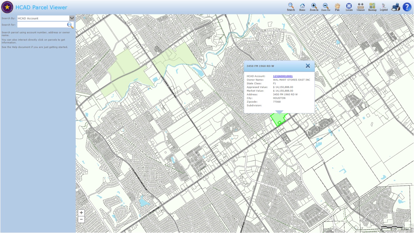
5. Check the property tax record. On the site we were using, we were able to get the tax information by just clicking on the property. The ownership info that popped up confirmed it’s a Walmart. To get more information, we followed the hyperlink to the full tax card.

6. Decipher the ancient mysteries of the tax card. On this page, you get all the juicy vital stats about your site. The contents and quality of this information can vary wildly between places. We were able to use this page to fill in all the fields in the form. We had to divide out the land area by 43,560 as it was stored in square feet instead of acres. What you’ll find on this page is a little hard to predict. Depending on the tax system you might find a few different numbers called total value. There’s often some kind of “full” value (higher) and some kind of “taxable” value (lower). The form has a place for two options. Make your best guess at the one used for taxes for “tax value.” Fortunately, in this case, there was only one option.
7. If the land area is not listed, use Google Maps to calculate. Some tax records may not list the size of the development. If that's the case, head over to Google Maps and look up your property there. Earth view will give you the most accurate results. Simply right-click near the development and you'll have the option to draw the perimeter of the development (make sure to include parking!) and get the total area. Note: The result will be measured in square feet so you'll need to convert to acres. Again, Google makes that easy for you.

8. If not listed, try to figure out how much county tax your site pays. Because tax systems vary so much between states, we’re interested in the actual tax bill too. (Note: This is an optional field on the data collection form, but if you’re able to fill it in, that will help out this project a lot.) A general county rate is sort of a common denominator. It may be listed with the other tax information but more likely, you’ll have to estimate it.
One easy way is to find a property tax calculator that does the work for you. Otherwise, you can estimate it yourself using the county’s property tax rate or mill rate. This is an excellent opportunity to learn more about how your community pays its bills and how your tax system works. You might find some surprises. Call up your local tax assessor or finance office if you need help. They are usually excited to share what it is they do.
9. Input your information. Fill in the information on the data collection form. If you have any questions, ideas or comments as you fill out the form, there's space at the end to add those.
10. Repeat for another building in your town. We’ve asked that after you fill in information for the Walmart in your town, you also find information for the tallest building in your town. Just reopen the form and start again with the new building. One tip: We recommend that you avoid condominiums as it tends to be complicated and challenging to calculate the tax value of the building as a whole.
11. Invite a friend to participate. This database will be most successful when people across the country fill it out. So send it to your friend who lives in a nearby town, or on the other side of the continent and invite them to participate.
Thank you for joining with us in this project. We'll keep you updated as the database grows and share the end project in the near future. (There's an opportunity to receive email updates from us on this project after you fill out the form.)
Josh McCarty and Rachel Quednau contributed to this article.