A Town Well Planned: Parcels and Master Street Plans
The following article is part of Alexander Dukes' ongoing series, "A Town Well Planned" in which he proposes his vision for municipal planning, inspired by his experiences as a United States Air Force Community Planner.
Read previous articles in this series:
The first article in the “A Town Well Planned” series proposed a three-part regulatory system for managing the design of urban environments. From here on out these articles will refer to this system as the “Civic Development System,” or “CDS” for short. The three pillars of this regulatory system are: (1) The Master Street Plan, (2) Basic Land Use Zoning Plans, and (3) Form Plans.
The next handful of articles in the “A Town Well Planned” series will use a single scenario to demonstrate how the three pillars of the Civic Development System can be leveraged to streamline and democratize municipal development. As we progress through the series, you’ll see how each of these pillars bolster and reinforce one another to provide localities and the civic planning profession with a solid framework for designing the urban environment.
This article will discuss how to arrange parcels within a Master Street Plan. Believe it or not, the best way to determine where streets should go is to determine the arrangement of parcel blocks first. That way, we can leave appropriate room for the streets and later design them to connect the space between the blocks.

I. THE SCENARIO
The theoretical scenario we will be exploring for the next few “A Town Well Planned” articles is situated on the site of the Auburn Mall, in Auburn, Alabama. For the purposes of this exercise, the Auburn Mall has closed due to its inability to attract customers to its anchor tenants—not unlike many other malls across the country. (The Auburn Mall is currently open for business, though two of its major anchors, Sears and JC Penny, have decided to close their doors.) The Auburn Mall had a gross leasable area of 527,000 square feet, and could support over 50 “stores and services.”
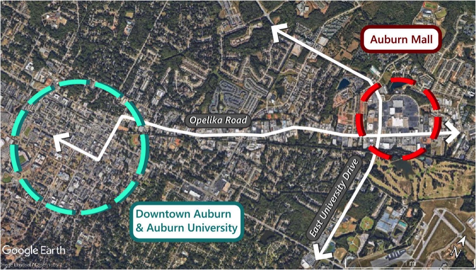
Geographically, the Auburn Mall is situated 2.7 miles from Auburn’s downtown core and Auburn University. Sited at the major intersection of East University Drive and Opelika Road, the Auburn Mall functioned as a second urban center for the city when it was constructed in 1973. Today, the site is situated a short drive from business locations for both downtown Auburn to the west and Opelika to the east. Though it would take about an hour to walk from the mall to the downtown, Auburn University offers an excellent “Tiger Transit” service to and from the mall site for students and employees. There is about a 30 minute wait time between Tiger Transit busses.
The owner of the mall parcel is looking to sell the property to developers to make a pretty penny in Auburn’s booming real estate market. However, in this scenario, redeveloping the site as a whole would financially require significant infrastructure investment from the City of Auburn. Auburn is only willing to make these investments if the platting of the new development corresponds with the city’s Civic Development System- particularly the Master Street Plan. Auburn’s Master Street Plan would require the huge mall parcel to be subdivided into a series of streets and many small parcels arranged on a grid. The city intends for these small parcels to be sold as individual lots that are affordable for middle class Auburnites looking to purchase or rent their first home or establish a small business.
After some consternation, the owner of the Auburn Mall realizes that breaking the site into many small parcels individually will allow him to make more money in the long run as opposed to selling the mall parcel in one go to a single developer. The owner accepts the platting of the Master Street Plan and subdivides his parcels accordingly. Moreover, because the mall site is undergoing a legally significant change, the new parcels that result from the subdivision must correspond with Auburn’s Basic Zoning Code and Form Plan.
II. THE PARCELS
To develop a subdivision design for the mall site, Auburn’s civic planners created a set of standardized parcels that can easily be advertised and sold to potential buyers:

Each parcel can be used as a whole, but teal and brown parcels can be subdivided at the discretion of the parcel’s final owner (after it has been sold by the mall owner). The teal colored parcels can be subdivided in two, while the brown colored parcels can be subdivided into four parts. Some permutations of the brown parcel’s subdivision will require the owner to establish a public easement through a parcel (see the dashed marks on some parcels) to prevent an alley terminating into a dead-end that traps pedestrians (this aspect will be addressed further in the Form Plan portion of the series).
The parcels designed by the planners are intentionally small, slim, and evenly divisible by one another. By having a relatively small square footage, these parcels are much more affordable than the typical suburban residential and commercial lots. By being slim, the green and purple parcels provide many more homes and businesses the opportunity to access valuable street frontage than is typical for other developments. (In fact, most apartments built today front a parking lot rather than a street.) And because the parcels are evenly divisible, the owners of brown and teal parcels can act as small scale developers, subdividing these parcels to establish small businesses like restaurants, barbershops, or micro-farms next to their homes. Brown and teal parcels can also be used whole for large apartment buildings, businesses or larger homes.
Despite their petite appearance, the four parcels types are wide enough to accommodate retail businesses, offices, apartments, and even single family detached homes- all with at least two parking spaces. Readers concerned with the size of the parcels should remember that lots of these sizes are eminently common in many downtown environments constructed prior to World War II. Some of the most beloved bars, eateries, and shops in downtown Auburn sit on lots that are even less than 25 feet wide.
Civic reserve parcels are public set-asides that the City of Auburn may use as it wishes. The city acquired these set asides in exchange for the infrastructure investments necessary to enable the development.
III. SUBDIVIDING THE SITE
Once the mall owner acquiesces to subdivide the parcel according to the Master Street Plan, the City of Auburn produces an illustrative map that depicts the arrangement of parcels that will be sold to Auburn families and entrepreneurs:

Parcels are arranged within the subdivision to be people-centered and car accommodating. Parcel blocks are spaced to both provide a wide street for parcels to front and a slimmer back alley for more utilitarian uses. These alleys are central to the city’s design. The key thing to remember here is that streets are primarily for people, while alleys are for people, cars, trash, deliveries, and any other housekeeping uses that should be generally kept off the street. This design choice clears valuable street space of nuisance uses and allows street frontage to be dedicated toward positive activities like outdoor dining, customer parking, or spontaneous recreational space. Alleys also grant more travel options for both pedestrian and automotive traffic to move through the area.
Notice that the negative space between blocks where the streets will go is not always straightly aligned. This is intentional for two reasons:
First, As Raymond Unwin conveys in his century-old classic “Town Planning in Practice,” there should be a sense of discovery within any town, and curves in the street help to evoke this sense of discovery. Curves do this by allowing the street scene to transform before your eyes as you walk through it. Essentially, curves keep things interesting.
The second reason some blocks aren’t straightly aligned is that curves help to slow cars down and provide a safer environment for pedestrians. Some spaces in the design would require curves so awkward for car traffic that they can only be used by pedestrians or cyclists. This is also intentional and will be discussed in the next article in this series where streets will be added to complete the Master Street Plan.
Finally, the subdivision design also allocates substantial space for two “civic reserve parcels.” The City of Auburn acquired these parcels in exchange for its agreement to provide the streets and infrastructure necessary for the subdivision to occur in the first place. The smaller reserve to the north will be used as a small recreational sports center, while the reserve to the south will perform double duty as both a park and drainage for the subdivision’s streets.
“When affordability meets flexibility, the result tends to be the democratization of a local real estate market.”
IV. CONCLUSION
As previously stated, the core objective of the parcels and subdivision design are to create spaces for residents that are both affordable and flexible. When affordability meets flexibility, the result tends to be the democratization of a local real estate market. In a democratized market, people naturally start experimenting to suite local tastes. In affordable and flexible spaces, large development companies with Wall Street financing tend to take a back seat to the innovation that can be found in the many hands of local entrepreneurs.
When you go to the bar in a community, the owner might be your neighbor who built the bar right next to his house after he saved up enough to start the place. Or you might pick up some local produce from the farm that another neighbor built on their rooftop. Both of these scenes are difficult to imagine in the bulk-construction, facsimile housing subdivisions we see today. The best way to achieve this community built by many hands is to offer plots of land at an affordable price, and allow the local residents and small developers living in cities to build them incrementally.
Hopefully this application of the Master Street Plan to the Auburn Mall site has demonstrated how platting small lots can greatly enhance affordability and to some extent increase flexibility. In the next “A Town Well Planned” article, we’ll discuss how the street itself can contribute a good deal of flexibility.
Read the next article in this series: "Street Design."
(All graphics created by Alexander Dukes)
Alexander Dukes (Twitter | LinkedIn) has been a regular contributor for Strong Towns since 2016, and works as a Community Planner for the US Air Force in California. He is a graduate of Tuskegee University and Auburn University, with a Bachelor’s in Political Science and Master’s degrees in Community Planning and Public Administration. With this background, Alexander focuses his planning work on public policy and urban design for both military and civilian applications. Alexander's goal is to build sustainable human environments that provide all citizens with access to cohesive communities, affordable housing, meaningful employment, and beautiful places.