How Zoning Codes Reinforce Car Dependency
Our series about Cobb County, Georgia in early August discussed the looming fiscal problems facing this suburban Atlanta county. We took Cobb County to task for its fragile development approach: Cobb County relies on growth to stay solvent, does not make a full or transparent accounting of its own debt levels, and subsidized a huge, risky megaproject—a new stadium for the Braves—while skimping on essential services and amenities for its own residents.
One thing we did not delve into in great detail was Cobb County's land-use regulations. Strong Towns member Antonio Graña wrote in with this analysis of how the zoning code of one of the county's cities, Marietta, essentially mandates low-returning, car-dependent development—even in its traditional downtown! We are sharing his commentary today as a guest article.
The picture below is a classic “stroad” intersection. It could be just about anywhere in suburban America, but this happens to be the intersection of Whitlock Ave. and North Marietta Parkway in Cobb County, Georgia. That stroads like this exist has become normal, but what’s striking about this image is that this is the entrance to the Marietta Central Business District. This is supposed to be downtown Marietta.
Marietta, Georgia. (Source: Google)
Strong Towns's recent series on Cobb County addresses the concern that the area's municipal budgets are overstretched, in large part because Cobb County's suburban layout couples the costly construction of new roads and utilities with development that returns a very low tax value per acre. When a new road (or stroad) is constructed in this environment, the municipality has taken on a potential liability, not an asset.
It’s normal for us to assume that roads are investments. After all, roads are necessary infrastructure for growth. The problem is that road design and requirements are now driven by zoning requirements, not market forces.
A typical example of "streetcar suburb" design. (Photo: Antonio Graña)
A century ago in Atlanta, streetcar suburbs were made viable through private transportation services—trolleys. The extension of a streetcar line was a real-estate venture: a new station made development possible in its vicinity, and that development paid for the cost of the line. The developers, in turn, understood the land uses and density required to keep the transportation system viable.
Today, these relationships are broken. In Cobb County, roads are built to drive a transportation monopoly around automobile use, the linkage to market forces and feedback is broken, and the capacity of the road is instead driven by zoning requirements. A more cost-efficient road network would improve the return-on-investment (ROI) of land value per tax dollar spent. In such a world, we might see a broader variety of transit options (car, transit, bike, pedestrian, scooter) and the more intensive land uses and densities that those options could facilitate. Unfortunately, in the current regulatory environment this simply is not possible.
Why We Build Stroads
Underlying decisions about what kind of infrastructure to build is a system of regulations that effectively mandates the monopoly on automobile use, which in turn induces spread-out suburban development, reinforcing the supposed justification for those same regulations. Here’s how.
Marietta is the one location in Cobb County that has what one could think of as a downtown. Its traditional development pattern predates the city's modern zoning codes. Yet those codes now prevent that pattern from expanding. A review of them reveals a long and lengthy set of regulations that are hard to untangle; it tells you everything from how much drainage must be built to the number of curb cuts. Two policies are key. Here’s section 716.03:
This is the type of regulation that allows public works departments to require developers and/or the municipality to widen streets to allow more vehicle capacity. It is directly linked to new development (and one would assume redevelopment). This is a huge inducer of overbuilt infrastructure. Every time a use is added or redeveloped it can become the case for wider roads.
But what drives the perceived need for wider roads? The answer is mandated parking. Look at Table J from the same section:
This is a sample of parking requirements for just a few land uses. For each increment of square footage used, off-street parking must be added. Note that a parking lot typically requires about 300 to 350 square feet of land per parking space, so the requirements in the above table can easily result in a 1:1 ratio (or higher) of parking to actual productive use.
When you plan development based on these types of regulations, you end up with a geometry problem. The sheer amount of land that must be dedicated to parking all but precludes walkable development, and so auto-oriented is the only option. Parking lots require stroads, and stroads require parking lots.
The outcome: More car storage than revenue- and value-generating uses.
So let's go back to downtown Marietta, which would seem to be Cobb County's exception to this pattern. But is it?
Source: City of Marietta, GA interactive public mapping.
In his August 8th article, Connor Nielsen discusses the need for a development pattern that creates productive growth. Downtown would be the most logical place to maximize the return on investment of land uses. Taxable lots are smaller, more finely grained, and therefore capable of delivering a higher volume of tax revenue over a diversity of uses. Marietta even has a rail line running right through downtown, though this is not for passenger use.
While there is a high density of lots in this area, one notices immediately the addition of major stroads—the wide roads visible near multiple edges of this aerial view—to support the automobile traffic that serves this compact development. As per section 716 of the zoning code, this is the result of the city and/or private owners repeatedly widening roads to support intensive land uses. Even in the downtown.
A Google Maps review of this area shows that in fact the vast majority of downtown has been converted to parking spaces! A selectively chosen view can obscure this fact. A photo of Marietta's downtown square presents what looks like a sterling example of good urbanism.
Source: Google
But in actuality, downtown really looks like this:
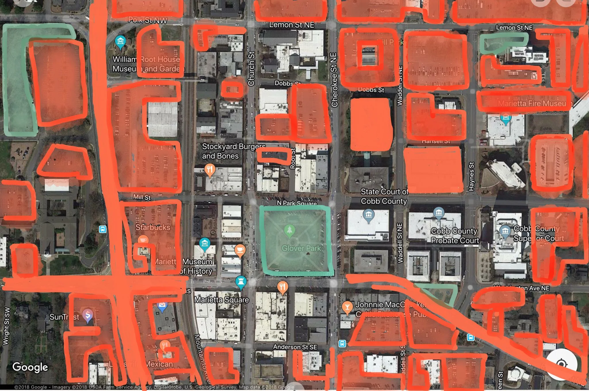
Source: Google with modifications by Antonio Graña.
I have added my markup based on a visual (and therefore not scientific) analysis of Google Maps imagery. My review of the city’s downtown parking zones corresponds highly to this image. Areas in solid orange represent parking structures and stroads built and dedicated to vehicles.
Remember that map of taxable lots? The ones that generate revenue or other value? Significant portions of those lots are shaded orange: they are dedicated to parking. All of sudden Marietta doesn’t look like a city anymore but rather a giant parking lot with a few buildings in it.
Marietta, Georgia is like many suburban cities: its regulations all but ensure a low ROI for the value of land. Zoning ordinances mandating parking, and the public works practice of increasing road capacity in tandem with new development, make it impossible to build new compact development. And over time they have even transformed a critical area for potential value—the downtown business district—into what is predominantly a parking lot.
This parking lot effect will only induce more driving and, as per the regulations, ever-wider roads and larger parking facilities. The challenges highlighted in Strong Towns's Cobb County series cannot be resolved until a thorough re-examination of these regulations is made. Cobb County's geometry problem makes it simply impossible to design areas where the ratio of land value to municipal infrastructure expenses can come into balance.
About the Author
Antonio Graña has a background as an advisor on managing complex organizational change. He draws his urbanism experience from living across the U.S. and abroad, his local community activism, and his service on local municipal boards. He lives in Hoboken, New Jersey.