A Town Well Planned
In this new series of articles, I hope to propose a three-part regulatory system for managing municipal design. While this initial explanation of the system may seem heavy handed, I encourage the reader to stick with the series. I believe this much simplified means of civic planning is more accessible and comprehensible for the average citizen, and will ultimately lead to better results for the public.

Photo from United State Mission Geneva
I. WHO PLANS?
The public has a fundamental right to define the nature of their urban environment. In the past, the nature of the urban environment was often defined by a king, lord, or general who obtained custody of the town or fortress and fashioned plans according to their own design. Today, we live in democracies whose governments are “of the people, by the people, for the people.” Thus, in the spirit of common law precedent, the nature of the urban environment must now be defined by the people. Don’t let any developer tell you otherwise.
The urban environment is and always has been, planned. To build any improved structure —from the most humble tepee to the Empire State Building— requires some level of foresight in the acts of designing and constructing the shelter. Towns and cities are composed of hundreds or thousands of buildings; therefore, towns and cities require planning no less robust than architects provide for a client’s building. Just as a building requires thorough, detailed architectural plans to affect good construction, so does a municipality need good plans to affect good development.
In most American towns and cities, the public has entrusted the design of the urban environment to civic planners organized into planning departments. The public acts as the “client” in this relationship while the planning department acts as the architect. To that purpose, planning departments design cities and towns through a system of plans and codes that regulate three key features of land development:
- The Arrangement of land - the design of the parcel, block, and street network applied to the land
- The Use of land - the purpose for which land is exploited (i.e. residential, office, industrial, etc.)
- The Form of land - the broad design of land improvements (i.e. detached/attached structures, etc.)
A thorough, detailed plan for municipal development will regulate all three of these features in a way that expresses the public consensus for how the town or city should develop. A vague plan will neglect one or two of these features, affording private interests the liberty to build outside of the public consensus.
II. THE INADEQUACY OF LAND USE ZONING
Today, planning departments design municipalities primarily through zoning code regulations. Zoning codes dictate how land is used by creating districts or “zones,” such as: residential, agricultural, office, commercial, or industrial. On the surface, this is good. Planners should broadly regulate land use to prevent conflicting land uses from harming one another. The problem is that land use zoning is often the only regulatory tool in most planners’ toolbox.
Take a look at an example of a typical zoning code:

In the code excerpt above, we see that the municipality is attempting to define the Arrangement, Use, and Form of residential land through a zoning district that is primarily concerned with Use.
Aggregating the three features of municipal land development into a zoning code severely limits planners’ ability to respond to the innumerable scenarios that they will encounter in the course of their duties. While there are a number of different districts to choose from (twenty for the residential land use alone in this municipality’s code), the Arrangement and Form land development features are applied out of context because the code is intended to regulate land use. This tendency to aggregate “arrangement” and “form” into the land “use” feature is part of the reason why most projects in municipalities must seek variances. For example, 80 percent of development projects in Ithaca, NY recently had to seek variances from its zoning code. As Better Towns and Cities writes:
Approximately 80 percent of building projects in the City of Ithaca go to the Board of Zoning Appeals [for variances from the zoning code], it was reported to Form Ithaca. That indicates the system needs fixing. The great majority of these requests are granted--but not before significant time and money is spent. ‘Uncertainty has a cost,’ says Ithaca developer Frost Travis. ‘You can’t get financing until you know if you are going to be able to do 28 or 36 units, and that could make the difference in whether you get loan approval at all. I'm intrigued by the idea of taking a 1,000-page code into a much shorter, visual, user-friendly document.’
So not only does regulating land development through a land use zoning code neglect the features of arrangement and form, it adds unnecessary cost and uncertainty to projects.
To realize the urban environment that the public desires, planning departments need regulatory tools that manage each feature of land development independently. A municipality should have one regulatory tool for the arrangement of land, another for the use of land, and a third governing the form of improvements on the land. These independent regulatory tools will allow each land development feature to be properly managed within its own discrete context. In the remainder of this article I will describe my vision for the nature of each of these tools.
III. TRIPARTITE LAND DEVELOPMENT REGULATION
1. Objective: Regulate the Arrangement of Municipal Land
Tool: Master Street Plans
The first and most important feature of land development is the arrangement of land into streets, and blocks. In the past, streets and blocks were realized through a master street plan. All of those beautifully rendered designs for cities like Washington DC, Savannah, and the Commissioners’ 1811 Plan for New York City are essentially master street plans. These plans promoted walking by using small blocks and frequent street intersections to shorten the distance between amenities. Subdividing the blocks into parcels typically permitted an intense mix of merchants and residences that democratized land development in the municipality.

Savannah, Georgia: “Oglethorpe Plan”
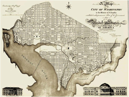
Washington, DC: “L’Enfant Plan”
Today, we have subdivision regulations, which are a mere textual description of some minimums and maximums developers should not exceed when developing land. A textual regulation like these can never achieve the geographic context of a purpose-designed plan. Further, many of the limits described are incompatible with a walkable environment. There are regulations out there with minimum block lengths of 600 feet and maximums of 1,800 feet. Most publications concerned with walkability suggest that block lengths should have a maximum of 600 feet.
All of these elements combine to make subdivision regulations an inadequate tool for arranging land. Because the blocks produced by subdivision regulations are so large, automobiles are a necessity to access the amenities on each block. This is why it is typical for these large blocks to host only one land use at a time rather than the mix of uses smaller, walkable blocks can support.
A town or city’s streets are its “bones.” Without good bones a municipality cannot hope to realize a public vision for its development. Planning departments should adopt master street plans so they can return the design of streets and blocks back to the public.
2. Objective: Regulate the Use of Developed Land
Tool: Basic Land Use Zoning
Land use zoning can still be a useful tool for affecting good land development. Without the baggage of the “arrangement” and “form” features, the zoning code has the ability to become much more simplistic and therefore more useful. Instead of having a “jack of all trades” (and master of none) zoning code containing twenty or more land use districts, municipalities can make due with ten or less.
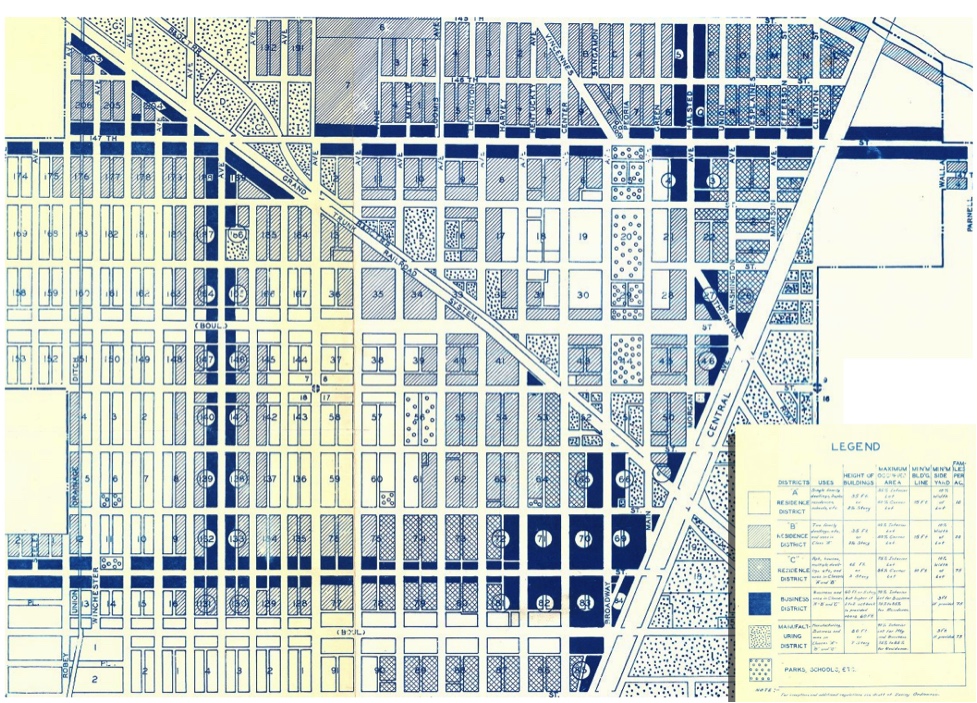
Harvey, IL Zoning Plan c. 1930, prepared by the city engineer (cropped and modified by Alexander Dukes to fit page). Original image source: The University of Chicago
As originally conceived, zoning was to be used in conjunction with a master street plan. This allowed zoning to operate in a very detailed, tight-knit way that was highly contextual to a municipality’s geography (see image above). Combined with a master street plan and a form plan, civic planners can manage land use with the nuance and attention to detail that the public often desires.
3. Objective: Regulate the Form of Developed Land
Tool: Form Plan and Form Based Codes
Form-based regulations like form plans and form-based codes are relatively new planning tools that regulate the broad design of improvements upon the land. A form plan is designed on top of a master street plan, and regulates each block according to its geographic context. Each block receives its own form settings for building mass, entrances, height, setback, and etcetera. A great example of a form plan is pictured below:

Carmel, Indiana Midtown Regulating Plan. Prepared by Speck and Associates. (Cropped and modified by Alexander Dukes to fit page)
To avoid clutter, more general form regulations that affect all buildings in an area should be handled outside of the form plan. These general form regulations should instead be included in a form based code. Appropriate regulations for a form code are: façade materials, roof design (flat or pitched), windows, porches, balconies, whether or not the building is attached to its neighbor, and etcetera. Used together, the form plan and form code are the final tools the civic planner needs in their toolbox to work toward the urban environment the public desires.
IV. CONCLUSION
A regulatory system that discretely addresses each core feature of land development is vastly superior to aggregating planning controls into a zoning code. By defining precisely what is and is not permitted within communities, municipalities can begin to fully realize the urban environments their public's desire.
Undoubtedly, there will be many that are wary of granting “the government” so much power to define the nature of the urban environment. I would respond by stating that there is nothing within this tripartite system that constitutes new authority for municipalities. Today, municipal governments regulate the arrangement of streets and blocks, the use of land, and building form. They simply fail to regulate any of those features effectively.
Seaside, FL is the pinnacle of “New Urbanist” planned communities. Seaside features development regulations with strict form codes, light land use codes, and was platted according to a master street plan. Seaside did not collapse under this “burdensome” regulation. Quite to the contrary, homebuilders and commercial real estate have flocked to the area, and copycat communities have been constructed as a result.
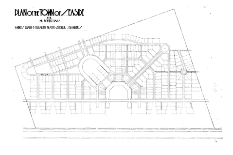
Plan of Seaside, FL c.1980 by Duany & Plater-Zyberg

Seaside, FL c.2010
In forthcoming articles for this series, I hope to explain in greater detail how ordinary citizens and government administrators can use a tripartite land regulation system to work better together toward the goal of a town well planned.
Read the next article in this series: "Determining Public Will."
Alexander Dukes (Twitter | LinkedIn) has been a regular contributor for Strong Towns since 2016, and works as a Community Planner for the US Air Force in California. He is a graduate of Tuskegee University and Auburn University, with a Bachelor’s in Political Science and Master’s degrees in Community Planning and Public Administration. With this background, Alexander focuses his planning work on public policy and urban design for both military and civilian applications. Alexander's goal is to build sustainable human environments that provide all citizens with access to cohesive communities, affordable housing, meaningful employment, and beautiful places.