Taco John’s 2.0

Taco John’s in Brainerd, MN. (Source: Strong Towns.)
A block that once housed a row of small, pedestrian-oriented storefronts is transformed, and in its place rises a shiny, new fast-food franchise restaurant, with parking, a drive-thru, and landscaping. The city gets new development, new jobs, and removes blight…right? The only problem: That fast-food joint is 40% less valuable than the “old and blighted” development pattern it replaced! If this scenario sounds familiar to you, it’s because I’m describing the development case study that put Strong Towns on the map for many of our readers: the infamous Taco John’s in Brainerd, Minnesota.
What that case study didn’t do is delve into the design choices that actually result in that less productive development pattern. It turns out that a few specific choices have an outsized effect—and that they could have been made differently, without even unduly compromising the developer’s vision for the Taco John’s. Let’s examine how.

Strong Towns has explored the math behind this project, and it is clearly not as productive as the older neighboring development on the same street. The Taco John’s development also deviates from the traditional urban pattern where buildings are built close to the street, where there are multiple uses of buildings, and different kinds of buildings on a block. These urban design decisions result in a less productive development. What would it look like, though, if the lot was arranged differently?
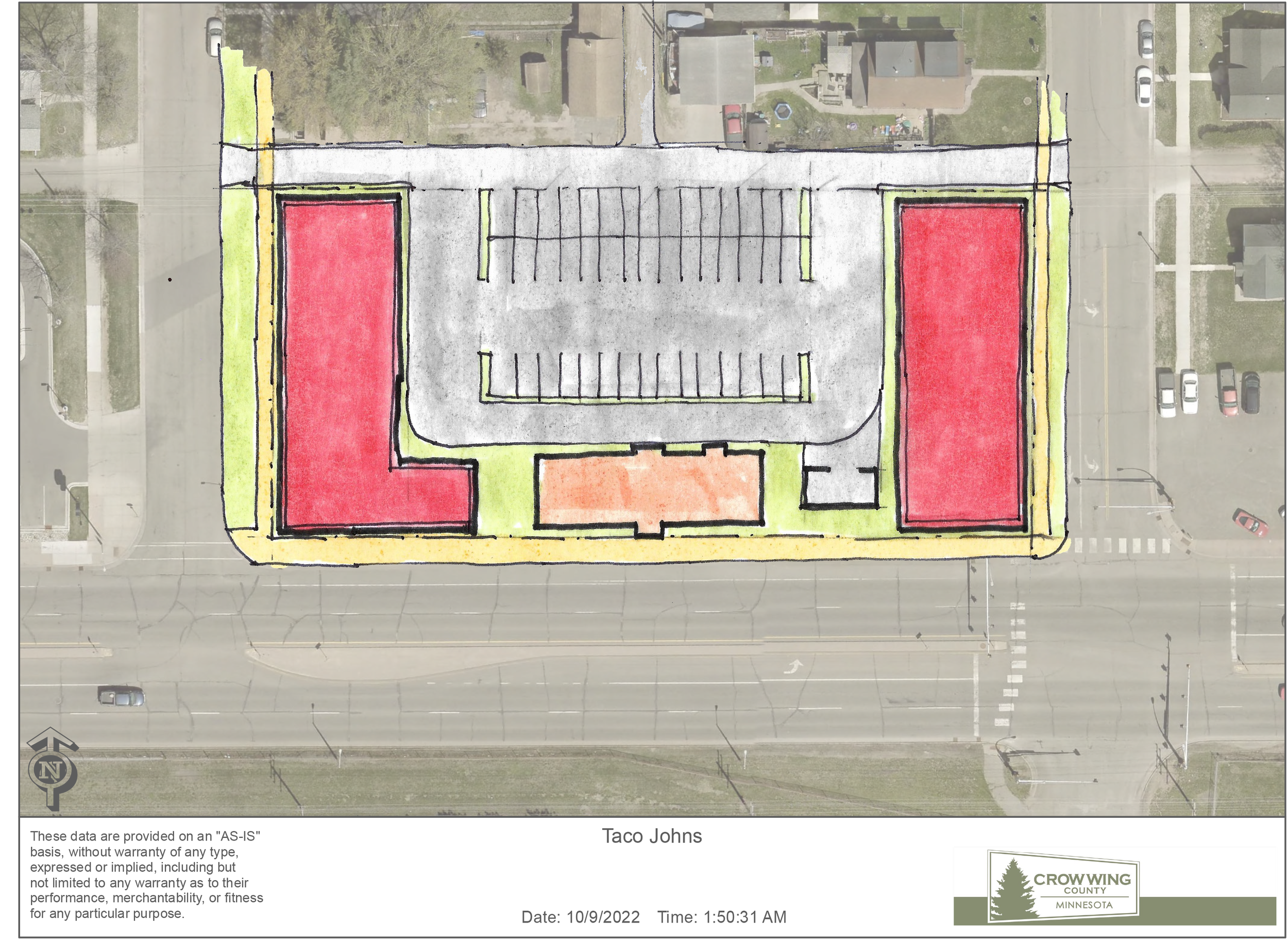
This site has several areas that highlight the inefficiency of the development:

Access onto Washington Street
If you’re an eastbound driver who wants to enter this lot from Washington Street (see above), you’re going to be blocked by the center median. Therefore, the “right-in, right-out (RIRO)” driveway that sits on Washington Street (indicated in red) is only usable by westbound drivers—and ultimately is redundant, since the two access points at the east and west sides of the site (indicated in green) serve the same purpose. So, why not just remove the driveway on Washington Street? In doing so, you’d resolve some of the traffic conflict in the parking lot (note how cars are getting bunched up in the photo as they try to access the drive-thru), plus you could fit in 3–4 additional parking spaces in the freed-up space.

Rear Alley
This location has the benefit of an existing rear alley (indicated in yellow), which could provide access to the residential and commercial buildings along the corridor. It’s an existing infrastructure investment, and yet Taco John’s isn’t using it, which means (again) that we’ve got redundant driveways, as well as multiple curb cuts (places where the sidewalk is interrupted by driveways), which are dangerous for pedestrians.

Parking Placement
The driveways that I’ve described above shape the overall lot in odd—and dangerous—ways. For instance, the curbs have a wide radius in multiple places, making it easier for cars to turn quickly, posing a danger to people trying to walk around them. The shape of the lot also impacts the number of available parking stalls and increases the total amount of paved asphalt on the site.

Landscape Buffers
Landscape buffers are shrubs or trees at the perimeter of the property that are intended to hide or screen the parking lot from the street. Unfortunately, the two-foot-tall hedge rows (indicated in purple) on the Taco John’s site do little to hide or buffer the parking. Landscape buffers are well intentioned when you place parking along a main street. However, as demonstrated here, they fail to meet that intent and instead turn potentially productive real estate into a grass strip that does nothing to enhance the site.
There are a couple simple changes that could be made to this lot that would yield a more efficient layout, even while preserving the drive-thru and parking. The following series of sketches explore placing the building and parking differently on the site. The floor plan and building footprint of this Taco John’s model is not changed, but there are some interesting consequences that result from moving it.

The first principle of urban development is to build to the street. The public realm is the area that includes the streets, sidewalk, and landscaping such as street trees, and within traditional development patterns, the public realm is framed by the fronts of buildings. The original buildings in our communities were placed along the street, and it’s also how the older portions of Washington Street are constructed.
By moving the Taco John’s building toward Washington Street, this suburban development transitions into an urban form and begins to frame the public realm. The front door, which is accessed by people, opens onto the sidewalk, and the drive-thru remains behind the building. The building becomes the buffer to hide all but a few parking spaces.
This layout results in greater exposure and increased visibility of the restaurant from the street. When the parking is consolidated into a more efficient parking lot to the rear of the building, the development yields more parking with the same amount of pavement. Assuming the current development met the required parking, this additional asphalt could be removed—and even more could be removed if the parking was accessed from the rear alley.
This plan may appear radical, but it only required one change. The building was simply located on a different area of the site. It required no changes to the building footprint or Taco John’s architecture. The queuing of the drive-thru probably increased and eliminated any conflict with access from Washington Street. The number of parking stalls increased with no additional asphalt.

Once the building is moved toward the street, additional site efficiencies become more evident. In this example, the vehicular access (the driveways) could be consolidated onto the rear alley, which is used for access for all the other developments along this street. The extra parking fronting Washington Street and adjacent to the drive-thru could be removed. This more efficient site would require less land, and would use fewer materials, which translates into a cheaper development to construct.
All of these little moves reveal the opportunity for a significant amount of “development-ready” vacant land fronting one of Brainerd’s most prominent streets. In this illustration, the red boxes represent two locations for future development that could conservatively support 10,000 square feet of additional development. This development would increase the productivity of this lot by emulating the patterns that currently exist in the community.
This study demonstrates how the arrangement of a site can hugely impact its productivity. In the Taco John’s example, just by applying a single urban design principle, we could make this site three times more productive than it currently is.


Conventional thought would tell us that the new commercial developments in a city should be the most productive compared to the older buildings downtown, but that’s not necessarily the case.