Build to the Street
A site plan for a new development has the opportunity to take on many forms. Each of these forms have a different resulting level of productivity. One of the universal principles of traditional urban design practice shared by planners and architects is to “build to the street.” The concept is simple and is intended to yield an urban form and character. When planning and siting new buildings, the buildings should be built up to the sidewalk or street frontage. The more urban the environment, the closer the building should be built to the street.
Building toward the street also yields several other noticeable benefits. First, when a building is front and center, all service items like parking and dumpsters are located at the rear of the building, or at the center of the block. The messy bits are screened by the architecture of the building instead of an expensive landscape buffer. Secondly, this is a far more efficient use of the site. The development can be maximized in plan to yield out more development. Parking lots that circle a building are inefficient and redundant to the public streets fronting the development. Features intended to mitigate the unpleasant impacts of parking in front, such as landscape buffers and screening, can also be omitted, which can result in at least a 20% improvement to the efficiency of the site. Finally, the architecture and street frontage of the building has the opportunity to shine instead of a sea of parking. This results in the adjacent development being vested in the success and maintenance of the public sidewalk and landscaping areas.
During a recent trip to Medicine Hat, Alberta, I spent the night at an airport hotel in Calgary. There is not a lot to do when staying at an airport hotel, and it provides the opportunity to reflect on your surroundings. The hotel was branded, and most likely a carbon copy footprint found in 60 other places across North America. However, with every building, the site layout is unique for this location.
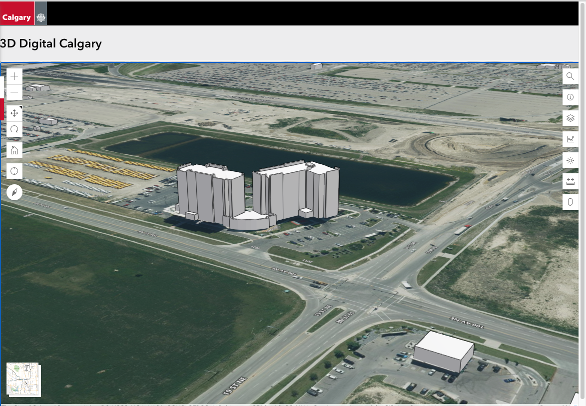
The development surrounding the Calgary airport has a very interesting street grid, which is slowly being developed with a variety of uses to support both travelers and the aviation industry. This development is an orderly development grid pattern with large, rectangular blocks. The streets are wide to accommodate large traffic volumes and truck traffic. Each street also includes sidewalks and street lights where pedestrians could walk. In this particular case, the hotel is plopped in the middle of the site and surrounded by an internal ring road and multiple parking areas.
The city of Calgary has invested in an extensive online map gallery, including 3-D models of the buildings in the city. This provides the opportunity to take the city’s mapping and illustrate a different layout for the site that can be visualized in perspective.
The hotel is pushed back from the street with a ring road and parking lots on two sides of the building. The hotel has two doors. One faces the public street and the other is on the rear, facing one of the two parking lots. There are no doors to access the hotel from the parking lot fronting the street.
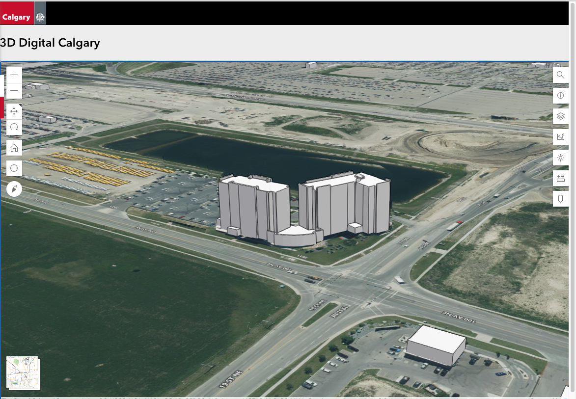
The 3-D digital mapping and a little photoshop provides an opportunity to explore this development differently. This example illustrates what would happen if the hotel was simply located closer to the property boundaries. By sliding the building to the street, an ambiguous street lacking distinct character and an edge has the opportunity to feel more urban, with a multi-story hotel fronting it. In this configuration, the parking area can be consolidated, which is more efficient and yields more parking.
The composition and arrangement of buildings described as an urban form encourages urban development and behaviors. For example, the hotel is approximately half a mile, or a 10-minute walk, from the airport. This 10-minute walk is faster than taking an airport shuttle or rideshare. The urban form supports urban street design, which Strong Towns has repeatability illustrated as a more productive pattern than highway development.
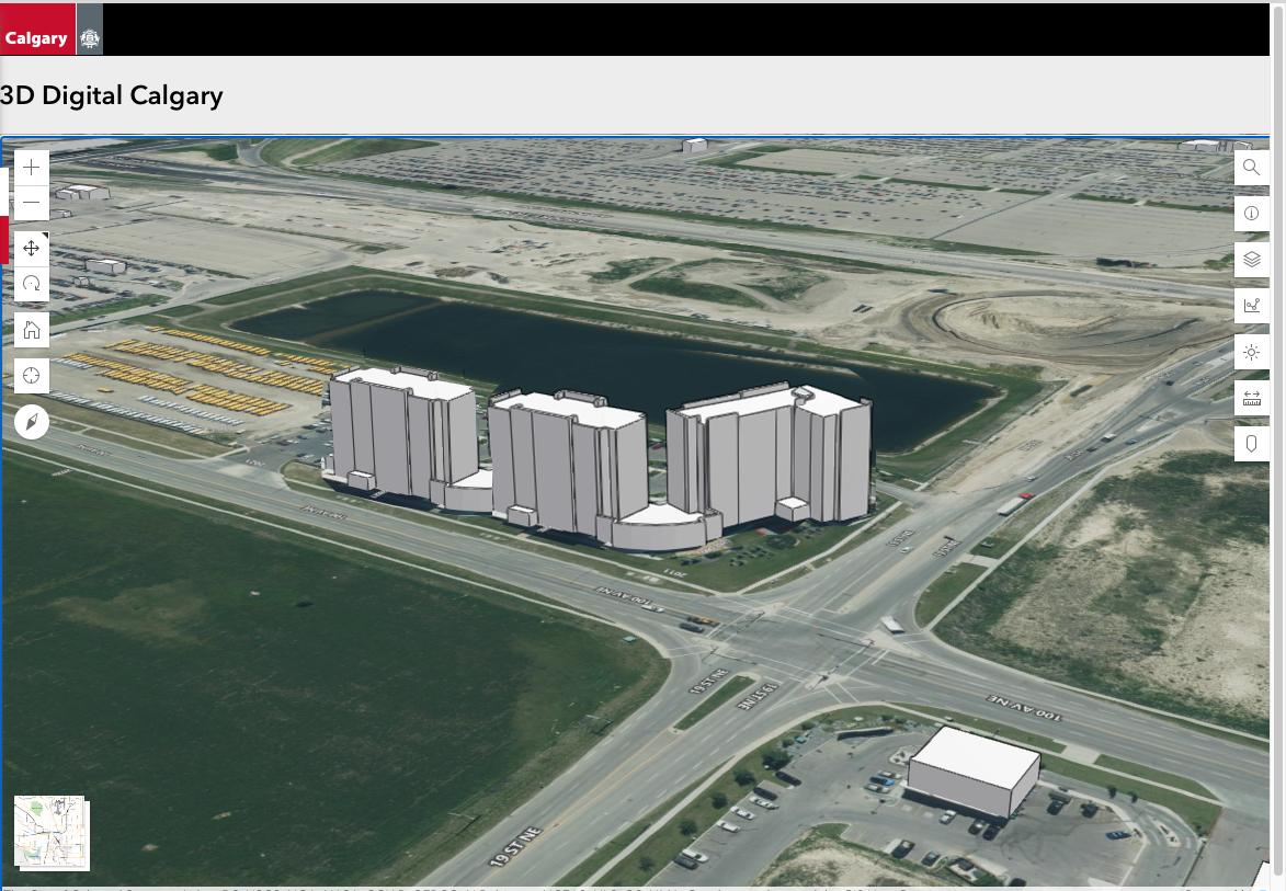
Building to the street creates a more productive site. Through the simple action of sliding the building, consolidating parking, and removing redundant systems, the site has the potential for more development. In this illustration, I was able to copy the footprint of one of the 135-room towers and duplicate it on the site. This additional tower uses the existing infrastructure, parking, stormwater management, and hotel amenities, but yields 35% more hotel rooms.
This is an example of what we describe at Strong Towns as “thickening” a community. The additional rooms translates into additional people at this location, which can support the development of new restaurants and business centers adjacent to the airport. This also translates into more productive land values and revenue to support the existing public infrastructure surrounding the airport.
The decisions and exploration in how to make a site more productive should occur early and often in the process. The mapping tool provided by the city of Calgary is a powerful means to look at sites not only in a two-dimensional plan, but in the third dimension as a virtual model. With this simple visual, we can do the math to see how this site could be more productive before the first foundation is ever poured.


Edward Erfurt is the Chief Technical Advisor at Strong Towns. He is a trained architect and passionate urban designer with over 20 years of public- and private-sector experience focused on the management, design, and successful implementation of development and placemaking projects that enrich the tapestry of place. He believes in community-focused processes that are founded on diverse viewpoints, a concern for equity, and guided through time-tested, traditional town-planning principles and development patterns that result in sustainable growth with the community character embraced by the communities which he serves.