36 Hours in Cincinnati: A Quick Crash Course in Placemaking
(Photo by Jake Blucker on Unsplash)
On Tuesday, May 14, I landed in Cincinnati with no expectations. I left it less than 48 hours later eager for an excuse to return.
My time in the Queen City was brief, so I covered limited ground. Accordingly, these observations are impressions, rather than assertions. I’ll never know what it’s like to live in Cincinnati full-time, but I know what it’s like to have clocked 30,000 steps in 16 hours.
Walking at Night
It was almost 11 p.m. when I reached my AirBnB in Over-The-Rhine (or OTR, as I saw it abbreviated on storefronts). This would be my first of two nights in the city, and no catalog of impressions would be complete without a night walk.
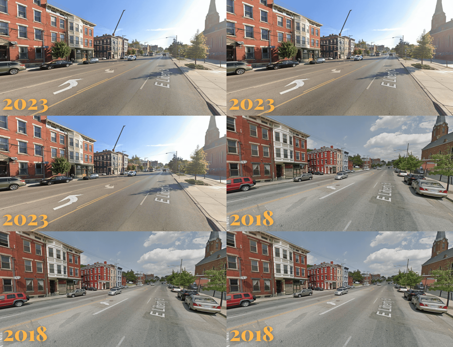
That walk began by crossing Liberty Street, known today for bisecting OTR. In the 1950s, the city widened the two-lane neighborhood street into a seven-lane arterial to shuttle vehicles onto Interstates 71 and 75. Nowadays, Fort Washington Way is the more popular funnel for anyone trying to connect to those regional highways, yet Liberty’s width remains.
The thing is, Liberty should’ve looked different in 2024. A decade ago, plans to narrow it from seven to five lanes wooed members of the city council. By 2019, these plans had only grown in popularity, but they were still sent to the drawing board — reportedly because of the mayor’s anxiety over the loss of parking. That birthed several alternatives, spurring an endless debate that left much of Liberty looking the same in 2024 as it did in 2014.
Across from my AirBnB, the only noticeable updates were a redone pedestrian island and a marginally widened sidewalk (which had ostensibly replaced a lane of parking). Seeing how little a decade of controversy produced reminded me of the pace of change in my own city.
I continued my walk and ended up on Main Street, which was bustling even on a dreary Tuesday night. The presence of people encouraged me to abandon Google Maps — a decision made even easier once I realized how much of the city settled into a grid — and allow myself to meander. There’s safety in numbers. I tucked away into a dive bar that was hosting an open mic.
Contrast this to the following night, when I zigzagged through downtown, which, at 11 p.m., was dead almost everywhere I turned. It’s not unusual for nightlife to buzz outside of a city’s downtown, but it was eerie to see how much was invested in the city’s world-class waterfront and then to experience how desolate it was at night, relative to other parts of the city.
Some of the contrast can be attributed to the fact that OTR’s renaissance is relatively recent, so it’s enjoying a honeymoon phase. Some of it may simply be the by-product of a downtown full of hotels, offices and facilities that rarely or never operate at night. Some of it might be a question of land use, particularly between downtown and the waterfront.
Accessing the city’s revamped waterfront requires crossing over both a below-grade highway and all the lanes that envelop it at street level. My colleague Edward Erfurt, who led a walking tour as part of the Strong Towns National Gathering, even joked that the surface street has more lanes than the highway beneath it. For reference, 2nd and 3rd Streets stretch Interstate 71 into a 330-foot mote. Each street has five lanes of traffic going in a single direction.
Erfurt lived in Cincinnati for a bit, so he’s familiar with its transformation. “There was this assumption that there would be all this traffic on 2nd and 3rd,” he told me. “Yet, it’s really not all that different from what you might see on 4th or elsewhere.”
Part of that traffic was supposed to come from regional travel, as those roadways easily connect to the city’s behemoth highway network. The rest was supposed to spill over from the two stadiums flanking either end of Smale Riverfront Park. However, several alternative roadways encase the stadiums, clearly designed to absorb whatever traffic they generate. Both the birds-eye-view (courtesy of Google Maps) and my on-the-ground experience left me questioning why 2nd and 3rd were so wide, given everything else available to drivers in the vicinity.
“I’ve heard lots of excuses for the downtown,” Erfurt shared. “And there’s this ever-present concern that heavy traffic will come eventually.”
Then, of course, I wondered why two stadiums that are situated within walking distance of downtown are catering to distant car travel so heavily, to the point that they sacrificed some of the most precious real estate in the city. Of course, Cincinnati’s growth pattern means that most people don’t live downtown, or even in OTR, so accessing anything in the city requires hopping into a car. At the same time, this type of land use only doubles down on that present reality, cementing it for the long haul.
To learn that the city is eager to begin construction on more roadways in this very area was disappointing, to say the least. It was also surprising, given that the downtown Cincinnati I experienced in the daytime seemed to be moving in the opposite direction. During the daytime, the city’s best attempts at placemaking were on full display.
Bollards. Bollards Everywhere.
“America needs a billion bollards,” Strong Towns founder Chuck Marohn wrote in 2021. “There is no coherent argument against lining every street in America with them.”
A sidewalk lined with bollards will ensure that the storefronts, streateries and people on it are protected from the full-scale impact of a wayward driver. They likewise safeguard entrances to parks and plazas. In cities like Philadelphia, where parking on the sidewalk is both under-penalized and a routine pain for anyone walking, bollards offer a subtle and affordable solution. At the very least, it’s cheaper and more impactful to install a handful of bollards than it is to deploy personnel to fine violators at all hours.
“If transportation professionals refuse to put up bollards to protect people from the violence of an errant vehicle, how is this not abetting the slaughter of thousands every year?” Marohn asks. If anything from morals to manuals will stand in the way of redesigning some of the country’s most crash-prone roads, the least we could do is install a billion bollards.
That’s why I was especially delighted to run into several bollard-protected plazas and streets in Cincinnati.
Most of the bollards I saw were retractable, so they could be raised and lowered as needed, allowing for controlled access by emergency or delivery vehicles. By sheer luck, I even stumbled upon the mechanism in action on Wednesday morning.
One of the most intriguing bollard placements I saw created a dead end on Broadway, a north-south corridor in the Pendleton neighborhood. I couldn’t help but envy the locals. The dead end not only creates a pocket oasis on 12th Street, but it also reroutes and slows down traffic that comes right off the expressway on the southern end of Pendleton. I could only dream of my own city being so ambitious.
That location was chosen as part of a 2021 streateries program, which funneled $3 million into small-scale placemaking in the city. As I visited some of the other streateries generated through that funding, I was happy to see that they were all still around three years later. They’ve long since disappeared in Philadelphia, and even New York City is looking to eliminate its curbside dining program.
Beyond bollards, the city was teeming with street closures, with one of the coolest being a roller-skating rink downtown. Strong Towns contributor Tiffany Owens Reed even captured the rink before it opened to the public. I’m obsessed with the simplicity: It’s just some plastic barriers, signage and an invitation to skate. This could be replicated virtually anywhere.
My favorite, perhaps, was the unsanctioned street closure near Findlay Market, where some neighbors ostensibly appropriated a couple of orange barriers stamped with “City of Cincinnati” to create their own car-free corner. It had none of the artwork or commerce of the other plazas, but it stood as a testament to how simple and rewarding it is to reroute traffic for just a few hours. I’m also a sucker for any rogue reclaiming of public space. It reminded me of summers in New York City when a friend’s uncle would make a fountain out of a fire hydrant. I never thought of it back then, but those DIY splash pads made for effective traffic-calming devices.
Along my route, I passed dozens more seasonal street closures, pocket plazas and parklets. Some were connected to larger parks and recreational facilities. Others were converted alleyways that, at some point, either stored trash bins or parked cars. Some were sponsored by local development corporations or nonprofits, and others were unmarked, perhaps set up by the city or locals. I didn’t ask. I was simply relishing in their ubiquity, encouraged by Cincinnati's embrace of the appetite that so obviously exists for these urban refuges.
Cincinnati is not dissimilar to many American cities. You can see hints of its glory days alongside the scars of its darkest hours. Its downtown is sliced by highways, much like the downtowns of Philadelphia, Houston and Seattle. And, like many of its neighbors, it’s only beginning to recover from decades of population loss and an outward growth pattern that’s only amplified its problems.
But what I saw in 2024 is a far cry from what existed even five years ago. Long-vacant buildings are getting a second life. Long-neglected neighborhoods are seeing private investment for the first time in decades. That change is probably equal parts exciting and scary, as change often is. This is where I often feel the most conflicted, especially as a tourist. Yet, if anything left me encouraged, it’s the hope that an elderly stranger expressed at one of the streetcar stops: “Everything changes. It has to. Like, we didn’t always have this streetcar. Now we do, and we’re better for it.” He then asked me for a cigarette.


Asia (pronounced “ah-sha”) Mieleszko serves as a Staff Writer for Strong Towns. A dilettante urbanist since adolescence, she's excited to convert a lifetime of ad-hoc volunteerism into a career. Her unconventional background includes directing a Ukrainian folk choir, pioneering synaesthetic performances, photographing festivals, designing websites, teaching, and ghostwriting. She can be found wherever Wi-Fi is reliable, typically along Amtrak's Northeast Corridor.